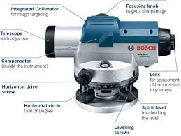
Automatic Level Instrument
An Automatic Level Instrument is used in surveying and construction to measure height differences and establish level points with high precision. It simplifies leveling tasks by automatically compensating for small tilts, ensuring accurate readings and efficient fieldwork.
Specifications:
Magnification: 32× – 40× (model dependent)
Accuracy: ±1.5 mm – ±2 mm per km double run
Minimum Focus Distance: 1 m – 1.5 m
Telescope: Fully coated optics for clear imaging
Leveling: Automatic compensator for tilt correction
Tripod Mount: Standard 5/8” thread
Applications: Land surveying, construction, civil engineering, road & bridge projects
Get Quote
Specifications:
Magnification: 32× – 40× (model dependent)
Accuracy: ±1.5 mm – ±2 mm per km double run
Minimum Focus Distance: 1 m – 1.5 m
Telescope: Fully coated optics for clear imaging
Leveling: Automatic compensator for tilt correction
Tripod Mount: Standard 5/8” thread
Applications: Land surveying, construction, civil engineering, road & bridge projects